| |
Canku Ota
|
|
|
(Many Paths)
|
||
|
An Online Newsletter
Celebrating Native America
|
||
|
September 2020 - Volume
18 Number 9
|
||
|
|
||
|
Drone Imaging Reveals
Pre-Hispanic 'Great Settlement' Beneath Kansas Ranch
|
||
|
by Theresa Machemer
-SMITHSONIANMAG.COM
|
||
|
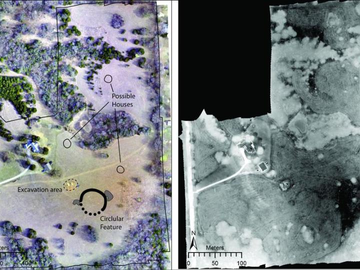
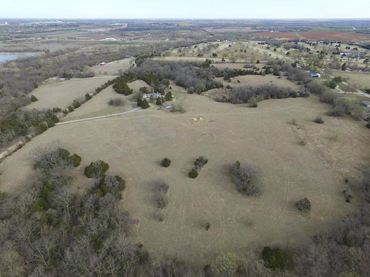
The 164-foot-wide
earthwork is the sixth ancestral Wichita "council circle"
discovered in the region
Archaeologists using new drone-sensing technology have found evidence of an enormous, horseshoe-shaped trench hidden beneath a Kansas ranch, reports Kiona N. Smith for Ars Technica. The rounded earthwork, which may be part of the largest pre-Hispanic settlement north of Mexico, appears to be what's known as a council circle. To date, notes Bruce Bower for Science News, researchers have identified five such structures across 22 sites in the area. Ancestors of the modern Wichita and Affiliated Tribes lived in what is now southeastern Kansas between about 900 and 1650 A.D. Per Ars Technica, they lived in grass-roofed pit houses; hunted bison; and farmed crops like squash, beans and corn. Over time, erosion filled the newly discovered earthwork with topsoil, concealing it from view. But modern sensors can detect subtle differences in temperature and foliage between the filled trench and the earth around it. As detailed last month in the journal American Antiquity, the researchers located the ditch through a combination of drone surveying and LiDAR, infrared and thermal imaging. Modern construction and farming have damaged many historic Wichita sites. Now, study co-author Donald Blakeslee, an anthropological archaeologist at Wichita State University, tells Science News, "We apparently have located the sixth council circle and the only one that has not been disturbed." Relic hunters who looted the region in the 1800s gave council circles their name, but the earthworks' actual purpose remains unclear. As Science News reports, researchers have previously posited that the structures served as the site of ritual ceremonies, housed community elites or offered protection from invaders.
In the new paper, the archaeologists suggest that sites including the just-detailed trench were part of Etzanoa, a population center dubbed the "Great Settlement" by Spanish conquistadors. Spanish colonizers first encountered Etzanoa in the 1590s, when an unauthorized group traveled north in search of Quivira, a mythical city of gold, according to Ars Technica. Though the expedition ended violently, one survivor managed to return and inform the Spanish of what he'd seen. In 1601, conquistador Juan de Oñate marched to the settlement, captured a resident and tortured him until he revealed the city's name. Archaeologists first excavated the site of the newly discovered council circle more than 60 years ago, Blakeslee tells Science News. But by 1967, they felt that they had discovered all of the mounds and earthworks located along Walnut River. Thanks to new technology, contemporary researchers have proven these predecessors wrong. Led by Dartmouth anthropologist Jesse Casana, the study's authors used nighttime thermal imaging to measure how daytime heat dissipated from the soil. The ancient ditch, which measures roughly 165 feet in diameter and 6.5 feet thick, is filled with looser soil than the tightly packed prairie around it; as a result, it holds more moisture and radiates less heat at night. Casana and his colleagues identified the ditch as a cooler, darker horseshoe shape in a warm landscape. They then followed up during the day with photography and infrared imaging. The team also reviewed previous aerial and satellite images, spotting the circular formation in photos taken in June 2015 and July 2017, according to a statement. Drone surveys "can truly transform our ability to locate sites and map important features where huge areas have been plowed and surface traces of houses and ditches are often close to invisible," Douglas Bamforth, an archaeologist at the University of Colorado Boulder who wasn't involved in the study, tells Science News. Blaeslee, meanwhile, says he plans to continue exploring the site with remote-sensing techniques, which will hopefully enable the team to develop precise targets for future excavations.
About Theresa Machemer
Etzanoa
Conservancy, Inc |
||||
|
|
|
|
||
|
|
||
|
|
||
|
|
||
| Canku Ota is a free Newsletter celebrating Native America, its traditions and accomplishments . We do not provide subscriber or visitor names to anyone. Some articles presented in Canku Ota may contain copyright material. We have received appropriate permissions for republishing any articles. Material appearing here is distributed without profit or monetary gain to those who have expressed an interest. This is in accordance with Title 17 U.S.C. Section 107. | ||
|
Canku Ota is a copyright ©
2000 - 2020 of Vicki Williams Barry and Paul Barry.
|
||
| |
|
|
|
The "Canku
Ota - A Newsletter Celebrating Native America" web site and
its design is the
|
||
|
Copyright ©
1999 - 2020 of Paul C. Barry.
|
||
|
All Rights Reserved.
|
||