| |
Canku Ota
|
|
|
(Many Paths)
|
||
|
An Online Newsletter
Celebrating Native America
|
||
|
March 2018 - Volume
16 Number 3
|
||
|
|
||
|
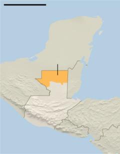
Lasers Reveal A Maya
Civilization So Dense It Blew Experts' Minds
|
||
|
by Jacey Fortin - The
New York Times
|
||
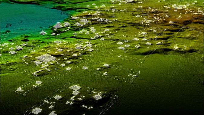
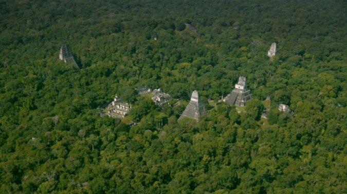
They were hidden there, all this time, under the cover of tree canopies in the jungles of northern Guatemala: tens of thousands of structures built by the Maya over a millennium ago. Not far from the sites tourists already know, like the towering temples of the ancient city of Tikal, laser technology has uncovered about 60,000 homes, palaces, tombs and even highways in the humid lowlands. The findings suggested an ancient society of such density and interconnectedness that even the most experienced archaeologists were surprised. "Everywhere that we looked, there was more settlement than we expected," said Thomas Garrison, a National Geographic explorer and an archaeologist at Ithaca College. "We knew there was going to be more, but the scale of it really blew our minds." Researchers found the structures by shooting lasers down from planes to pierce the thick foliage and paint a 3-D picture of the ground below. The technology is called Light Detection and Ranging, or lidar.
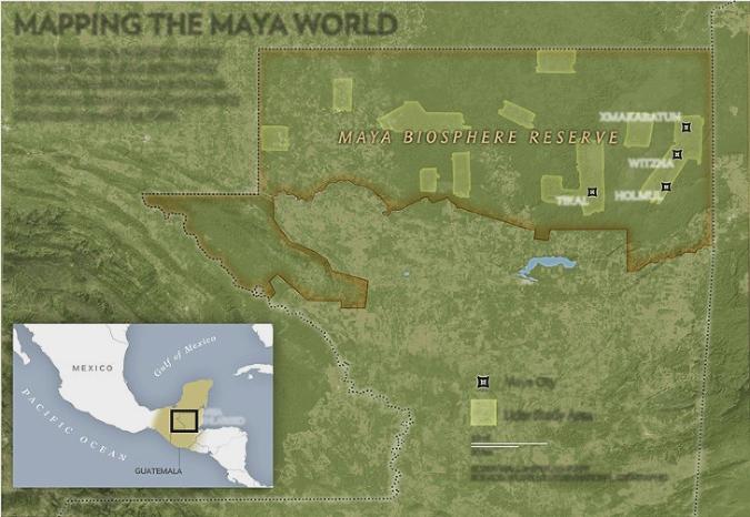
The method has been used elsewhere, including around the Angkor Wat temple in Cambodia. But this lidar project is the largest ever undertaken. More than 800 square miles of the Maya Biosphere Reserve in Guatemala's Petén region have been mapped, according to an exclusive report by National Geographic, which is airing a Feb. 6 television special about the project. "This world, which was lost to this jungle, is all of a sudden revealed in the data," said Albert Yu-Min Lin, an engineer and National Geographic explorer who worked on the television special. "And what you thought was this massively understood, studied civilization is all of a sudden brand new again." The lasers are only the first step, he added, noting that he and archaeologists still had to trek through jungles to verify the data while contending with thick undergrowth, poisonous snakes, swarms of killer bees and the odd scorpion.
The project was started by Pacunam, a Guatemalan nonprofit organization, and carried out with help from the National Center for Airborne Laser Mapping, which is based at the University of Houston. The lidar technology essentially allows researchers to spot bumps in the landscape. Most of the ruins look like rocky mounds — even in person, and to the naked eye — but experts can often identify a collapsed quarry, palace or street. With help from supporters, Pacunam has spent more than $600,000 on this first phase of the lidar project, said Marianne Hernandez, the president of the board. The organization hopes to use the laser technology to map the entire Maya Biosphere Reserve. But it is not only about protecting cultural treasures, Ms. Hernandez said. The project is part of a broad push to fight climate change, generate tourism dollars and prevent illegal activities like border trafficking and deforestation in protected areas. "This is a Guatemalan effort," she said. "We need to marry the interest in pursuing scientific stories with our interest in finding a sustainable model for the area." Ms. Hernandez began planning the project in 2015 with archaeologists like Marcello Canuto, director of the Middle American Research Institute at Tulane University. The laser-equipped planes flew over Guatemala in 2016. And when Dr. Canuto and his students finally saw the preliminary data about a year ago, "We could not peel our eyes off the T.V. screen," he said. "It's being blind, and then being able to see."
The Maya culture was known for its sophisticated approach to agriculture, arts and astronomy. The peak era for the civilization, which some archaeologists refer to as the Classic Period, is generally considered to have lasted from around A.D. 250 to 900. The total population at that time was once estimated to be a few million, said Diane Davies, an archaeologist and Maya specialist based in the United Kingdom. But in light of the new lidar data, she said it could now be closer to 10 million. Dr. Davies was not involved in the lidar project but considered it "really big, sensational news." She said the data should encourage people not only to re-evaluate Maya civilization, but also to learn from it. "To have such a large number of people living at such a high level for such a long period of time, it really proves the fact that these people were highly developed, and also quite environmentally conscientious," she said. Among the structures uncovered were roads, built wide and raised high above the wetlands to connect fields to farmers and markets to metropolises. There were also small dwellings, quarries and intricate irrigation systems. "We're seeing the spaces in between, and that's where really interesting stuff was happening," Dr. Garrison said. He added that in addition to changing people's perception of the Maya culture, lidar represented "a sea change" in the field of archaeology. "I don't think you see a lot of discoveries happening across the sciences right now that sort of turn a discipline on its head," he said. "It's exciting to know that it can still happen."
|
||||||||||
|

|
|
||
|
|
||
|
|
||
|
|
||
| Canku Ota is a free Newsletter celebrating Native America, its traditions and accomplishments . We do not provide subscriber or visitor names to anyone. Some articles presented in Canku Ota may contain copyright material. We have received appropriate permissions for republishing any articles. Material appearing here is distributed without profit or monetary gain to those who have expressed an interest. This is in accordance with Title 17 U.S.C. Section 107. | ||
|
Canku Ota is a copyright ©
2000 - 2018 of Vicki Williams Barry and Paul Barry.
|
||
| |
|
|
|
The "Canku
Ota - A Newsletter Celebrating Native America" web site and
its design is the
|
||
|
Copyright ©
1999 - 2018 of Paul C. Barry.
|
||
|
All Rights Reserved.
|
||