| |
Canku Ota
|
|
|
(Many Paths)
|
||
|
An Online Newsletter
Celebrating Native America
|
||
|
February 2013 - Volume
11 Number 2
|
||
|
|
||
|
OLC Teacher
Maps Out Lakota Culture, Past, Present, and Future
|
||
|
by Christina Rose ...
used with permission
|
||
|
credits: Native Sun News
|
 Oglala
Lakota College teacher Jim Sanovia has proven that there is a lot
more to maps than finding your way from Point A to Point B. Sanovia
has taken the concept of mapping and used it to identify abandoned
uranium mines, sacred sites and even areas of creation stories such
as the red racetrack, which really does circle the Black Hills, and
the Salamander and Turtle. Oglala
Lakota College teacher Jim Sanovia has proven that there is a lot
more to maps than finding your way from Point A to Point B. Sanovia
has taken the concept of mapping and used it to identify abandoned
uranium mines, sacred sites and even areas of creation stories such
as the red racetrack, which really does circle the Black Hills, and
the Salamander and Turtle.
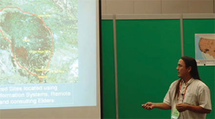
"We always felt like we were already scientists," Sanovia said with obvious excitement about his finds. "Now this stuff helps us explain things, like why the wind blows and like oh, there is the race track, we have these satellite images!" Sanovia marvels about his ancestors understanding of the land. "How did they see it was a racetrack, it was so huge? There is Pe Sla and it's round, and there is the salamander, how did they know what the salamander looked like? It's huge! It is probably half the size of Rapid. How do you see that from the ground?" Pointing to photos, Sanovia shows the turtle, "Here is the head, here are the legs, these are so big, each of these!" As an undergraduate majoring in pre-engineering, Jim applied for a NASA internship and was accepted in a program for satellite mapping, arial photographs, and digital layering. He had attended Central High School in Rapid City where he says he graduated close to the bottom of his class, number 472 out of 475. "I was told by the school system that I couldn"t do anything but be a painter or a carpenter, and I kind of grew up thinking I was okay with that. But I went to NASA and just learned these cool things and wondered how could I use these for other cool things. That's when the cultural ideas started." At the time, Jim was attending a tribal college and was taking culture classes alongside the science classes, and he said, "Things just started to mix." As he learned the new software for engineering applications that had layering and slope ability, he realized he could use it to display Bear Butte in 3D and that these maps could be used for a cultural speaker's presentations. "How cool is that? I always called those projects my project converts." While Sanovia wasn"t the first person to hit upon the idea of mapping culture, he credits Jhon Goes In Center, tribal advisor for the Historic Preservation Office in Pine Ridge and a founder and former President of Innovative GIS Solutions, Inc. of Ft. Collins, Colorado, as being too far ahead of his time. Goes in Center said that maps are too often thought of within the western mindset. While developing cultural mapping in Canada, he found that the state defined maps "as a document of an area that you consider to be yours." But according to Goes In Center, the Native maps offer information that portrays an indigenous world view, and can show the relative importance of the "tenure of the land, subsistence data that they survived with over many millennia, maps for species of trees, the hydrology water ways, the whole medicinal plant maps, food sources." He added, "It all overlays the data. You still have to cordinate it with GPS units, and map around a whole area. These maps are sophisticated, but we can use it as a communication tool, like a book." Goes In Center said that mapping is not new to Native technology, and noted that Star Knowledge is a map. In his position as Tribal Advisor for Historic Preservation, he believes that although more people may be aware of technology, many still fear it's cultural uses. However, Goes In Center explained that mapping is not new to Indigenous thinking and has long been a way to interpret home lands. "The Inuit carve on ivory. They carve their three dimensional maps they can hold in their hand. Great Lakes Tribes made maps on birch bark, in a relational way, by mapping the resources that are there." Charmaine White Face, director of the Defenders of the Black Hills, has used the maps to note abandoned uranium mines. White Face said that there are 3,272 abandoned mines within the Treaty Territory in South Dakota, Montana, Wyoming, and North Dakota, and in the past, she said it was difficult to describe to uranium companies exactly where a sacred area might be. But with Sanovia's maps, she is now able to describe the locations of burial grounds and abandoned uranium mines to new mining companies coming in. "As far as sacred sites go, in the past we couldn"t stop them, and we are hoping with the maps, we will be able to stop them," White Face said. "Since the 1850s, there was a place where there are 1,400 burials in North Dakota. Without being able to say here, here, and here, we couldn"t stop them from mining. There are areas like that throughout the Great Plains states." Sanovia said using the maps in this way also helps introduce culture to engineers through the visualization. While holding a map, Sanovia explained, "Here's our watershed. There is all kinds of water sampling, all kinds of projects, going on in here. We can"t just use the rez border as our research area, it wouldn"t be scientifically correct." Besides being able to help other scientists and engineers understand land beyond borders, sacred sites and mines, Sanovia says there are other uses. "The Oglala Lakota College wanted to know how our cotton woods trees are doing. They are trying to think of how many sun dances we have each year. If there are a couple hundred, that's a couple hundred cottonwood trees going, so how are they doing? We did a cotton wood tree analysis with these same tools, and we found out they are doing okay." Sanovia now names everything on his maps in the Lakota language. He started yet another mapping project with Dr. Victor Douville, Rosebud historian. Together with elders, they worked on returning Lakota names to major creeks and stream in a region of eight or nine states. From Northern Kansas all the way to Eastern Colorado, Montana, Wyoming, Minnesota, and beyond, the group found that many of the names originated in Lakota in the first place. "We were just renaming them. Battle Creek, War Bonnet Creek, Turtle Creek, all were translated directly from Lakota," Sanovia said. "We made history when we made the first map using Lakota place names," Jhon Goes In Center said. "All this technology is a renaissance relating back to our homeland. We are getting connected to our sacred spaces again. Right now, we are referring to our identity through our recent history. We need to start using our sacred sites, instead of talking about them." (Contact Christina Rose at christinarose.sd@gmail.com) |
|
|
||
|
|
||
|
|
||
|
|
||
| Canku Ota is a free Newsletter celebrating Native America, its traditions and accomplishments . We do not provide subscriber or visitor names to anyone. Some articles presented in Canku Ota may contain copyright material. We have received appropriate permissions for republishing any articles. Material appearing here is distributed without profit or monetary gain to those who have expressed an interest. This is in accordance with Title 17 U.S.C. Section 107. | ||
|
Canku Ota is a copyright ©
2000 - 2013 of Vicki Williams Barry and Paul Barry.
|
||
| |
|
|
|
The "Canku
Ota - A Newsletter Celebrating Native America" web site and
its design is the
|
||
|
Copyright ©
1999 - 2013 of Paul C. Barry.
|
||
|
All Rights Reserved.
|
||