![]()
Canku Ota
![]()
(Many Paths)
An Online Newsletter Celebrating Native America
May 31, 2003 - Issue 88
![]()
Walking In The Sand ...
Conclusion: Part Four
by Awo Saw Duk
|
|
Canku Ota |
|
|
(Many Paths) |
||
|
An Online Newsletter Celebrating Native America |
||
|
May 31, 2003 - Issue 88 |
||
|
|
||
|
Walking In The Sand ... |
||
|
by Awo Saw Duk
|
||
|
Today's challenge was for our canoe's
to make a fifteen-mile journey south to the Quinault village of Queets.
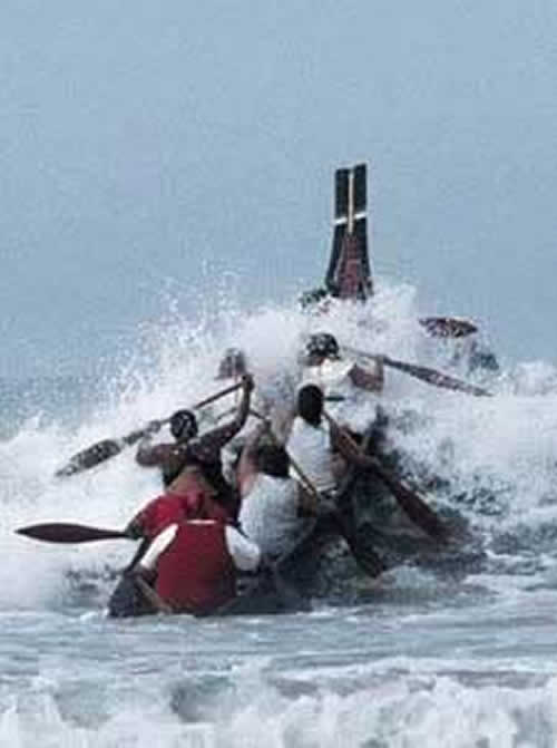
Departing the shores of Hoh was actually quite amusing. The canoes passed
through the mouth of the Hoh one by one. Some of them shot through virtually
unaffected by the oceans swells while others were caught in, on, and
above the swells. These crews were fun to watch while anticipating large
swells that would toss them about and thinking that we were going to
be one of the last to pass through while the swells were building ever
higher ... Our turn was a bit intimidating, watching and counting
the swells, one, two, three, four, and five. The crew leaning forward,
eyes staring straight ahead, paddles at the ready, awaiting my voice
command of "Paddles In, Weela! Weela! Weela EEE!!!"
The morning paddle felt good as we traveled
just outside of the breakers along the shoreline, feeling the oceans
mist on your face while riding though the troughs of big swells. Low
hanging clouds clinging to the treetops of the evergreen rainforest
were quite the sight to see as we rode up and over the tops of swells
and back down into the troughs where all you could see was a wall of
water on both sides of you. The sounds of the breaking surf becoming
louder and louder as the height of the swells grew became more and more
intimidating. As we rode over the tops of the swells I also began noticing
that fog banks were developing both onshore and out on the sea and recognized
that it would soon engulf the entire coastline. This was becoming quite
concerning whereas this portion of the shoreline has some rather large
rock outcroppings scattered about and not to mention Destruction Island
(at the time we did not want to think much about the name of island
as much as acknowledging that it was there) all this making it very
dangerous for our canoes and support vessels to be traveling through
these waters. These conditions were making our journey very dangerous
whereas all our canoes were stretched out in a single file extending
for miles. There were a few canoes that stayed close together and this
was good because some of these canoe crews had never been out on the
open ocean. By now, the fog had become so thick you could barely see
from one canoe to the other and soon the fog conditions became even
worse, were you could barely see from one end of the canoe to the other.
For our crew, these conditions did not bother us too much, for myself
anyways. I have been exposed to many situations such as these and relied
upon my past experiences traveling through and working on these waters
in conditions much greater in danger than these but this time, we had
twenty-five canoes out in the fog. Support boats were frantically calling
to each other trying to determine their positions in contrast to other
crews and support vessels. A few of our vessels had Geographical Information
Systems on board. Some had Radar Systems on board. Some had both systems.
Some had none ...
The life saving instincts that I learned became very precious at this time. As we encountered ever-increasing dangers I managed to keep our crew calm and functional. I found strings of crab pots that were laid out in north to south directions that I confirmed on my compass that was attached to my windbreaker coat. We followed these pots and kept the swells, which I knew to be southwesterly swells to our starboard side knowing that we were outside of the danger areas of the large swells, rock outcroppings, and breaking surf. The sounds of a support boat soon became audible then the outline of a canoe became visible. We had come across one of Tulalips canoes.
We called out to them informing them that we were underway and headed
for Point Grenville, another thirty-five miles away. So, we were on
our way, Tulalips following our lead, traveling through fog so thick
the light from the sky was a grim dark gray. Being in conditions like this really sharpens
your senses. We could hear sea birds chattering that we hadn't
noticed previously. We could hear sounds of vehicles being driven on
the highway which, was a way of telling how far south we were getting
because the highway turns away from the ocean as you get into Queets
territory. By this time were running out of crab pots to follow and
the sounds of traffic were no longer audible so I had to rely on my
compass (those of you who have used compasses in forested areas on land
know the feeling of when you think your compass is wrong and you want
to change directions, well, imagine being out on the ocean, in the fog
and having that feeling,,, good thing I knew the ocean swells direction
confirmed my compass bearings). About this time the winds began picking
up. The winds began kicking the sea up into conditions
that are referred to as Small Craft Advisory conditions by the United
States Coast Guard. The conditions we encountered were one to three
foot high choppy waves on the top of the sea's regular swells. We had
maneuvered our canoe out far enough to be outside of the large swells
but the ocean did give us didn't allow us any smooth sailing. At this
time, the Tulalip support vessel was receiving distress calls from many
other support vessels. These vessels were trying to group up all the
canoes and travel the extra thirty-five miles together. We could hear
horns from boats in towards shore moving out to safer waters. My crew
had to slow our progress and at times go back and search for the Tulalip
vessel. This was really time consuming and energy consuming to our crew.
Eventually we grouped up with many other canoes and support vessels
and slowly, worked our way for hours, to Point Grenville. The National
Oceans and Atmospheric Administrations research vessel Tattoosh was
very instrumental in getting our canoes and support vessels to our seemingly
endless destination and I would like to thank them, Siokwil, for I believe
that if not for their assistance, we would have lost some of our people
to hypothermia and to the sea. When we did arrive at Point Grenville, I saw
flares shooting up from and over the water for the first time. This
was quite the site while coming up on my Quileute cousins who were waiting
in their canoe and support vessel just of the point and followed us
in to shore. We could see lights shinning from the shore, from vehicles
that were parked along the beach trying to signal us in to safe waters.
As the Tattoosh tossed our lines clear from tow, we paddled towards
the beach with a great desire to get back on land and to see that everyone
be comforted as much as possible whereas we realized some of the canoes
were unaccounted for and some crew members were unaccounted for. As
time passed all the emergency actions that we all exercised enabled
us to arrive at our extended destination as safe as possible. For some
of us pullers who have many years of experience, this was not our most
challenging experience whereas I know personally that there have been
many moments where our canoe crews have met and conquered some of the
most death defying events while at sea. Once on land, some people kissed the sand,
others embraced family members, while some raised their hands in Thanks.
Some just sat at the fires that were built on the beach and stared into
the fire.
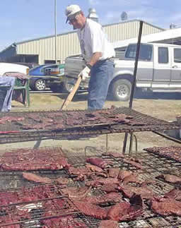
Staring into the community fire-pit in the
village of Taholah was much more pleasurable. There were hundreds of
Quinault Sockeye Salmon, commonly known as Blueback, cooking on sticks
over alder fires with deer meat and elk meat on racks right beside.
Gallons and gallons of clam chowder, fry bread, and pies awaited the
guest. Each day hundreds of volunteers prepared meals throughout the
day, conducted emergency services, communications and coordination services,
and community services. The National Guard provided assistance and facilities
for sanitary purposes. The whole community had come together to host
the thousands and thousands of visitors who came to Celebrate Tribal
Journeys.
For myself, after many years of traveling
all throughout Tribal Country, from the Atlantic Coast to Pacific Coast,
from the Gulf of Mexico to the Gulf of Alaska, for me, these were Very
Special Times, coming Home to Quinault, While Walking In The Sand ...
|
||||||||||||||||||||||||||||||||||||
|
|
||
|
|
||
|
|
||
|
|
||
| Canku Ota is a free Newsletter celebrating Native America, its traditions and accomplishments . We do not provide subscriber or visitor names to anyone. Some articles presented in Canku Ota may contain copyright material. We have received appropriate permissions for republishing any articles. Material appearing here is distributed without profit or monetary gain to those who have expressed an interest. This is in accordance with Title 17 U.S.C. Section 107. | ||
|
Canku Ota is a copyright © 2000, 2001, 2002, 2003 of Vicki Lockard and Paul Barry. |
||
| |
|
|
|
The "Canku Ota - A Newsletter Celebrating Native America" web site and its design is the |
||
|
Copyright © 1999, 2000, 2001, 2002, 2003 of Paul C. Barry. |
||
|
All Rights Reserved. |
||
Thank You
![]()
 This
day completed our stopover at the village of the Chalat people, territory
of the Hoh Tribe. The signs of nature this morning were telling me that
the weather was changing. Observing the seagulls flying about anxiously,
hearing the breathes of the wind blowing through the tree tops, feeling
the moisture in the air (and more so on our tents as we shook them dry
to store them for our next stopover) made my instincts hint to me that
today was not going to be smooth sailing day especially as we watched
canoe after canoe, shoot through the mouth of the Hoh River, with the
first canoes encountering gentle ocean swells while the following canoes
encountered the ever increasing roughness of the ocean's mystical powers.
The sight of one of our canoes being hit by a huge wave and shooting
nearly straight up in the air flinging paddlers out into the water confirmed
to me that today was not going to be a smooth sailing day, one that
would evolve into one of our greatest challenges, While Walking in the
Sand ...
This
day completed our stopover at the village of the Chalat people, territory
of the Hoh Tribe. The signs of nature this morning were telling me that
the weather was changing. Observing the seagulls flying about anxiously,
hearing the breathes of the wind blowing through the tree tops, feeling
the moisture in the air (and more so on our tents as we shook them dry
to store them for our next stopover) made my instincts hint to me that
today was not going to be smooth sailing day especially as we watched
canoe after canoe, shoot through the mouth of the Hoh River, with the
first canoes encountering gentle ocean swells while the following canoes
encountered the ever increasing roughness of the ocean's mystical powers.
The sight of one of our canoes being hit by a huge wave and shooting
nearly straight up in the air flinging paddlers out into the water confirmed
to me that today was not going to be a smooth sailing day, one that
would evolve into one of our greatest challenges, While Walking in the
Sand ... 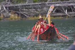 We
actually made it out to sea with no problems. We cut through a couple
swells and over a couple larger ones that made the experience quite
exciting. Exciting enough to make us want to go back and try it again
but out to sea, on to the south we had to go. Paddling along the coastline
in the early morning, we began our ritual of singing songs and telling
stories of the past night's Potlatch. These part of our journeys are
always fun because we have so many paddlers with so many stories to
tell (some of them are really funny) and we make songs for certain ones,
such as the Mosquito Song (for a certain somebody who will be getting
a bit embarrassed while reading this :)~
We
actually made it out to sea with no problems. We cut through a couple
swells and over a couple larger ones that made the experience quite
exciting. Exciting enough to make us want to go back and try it again
but out to sea, on to the south we had to go. Paddling along the coastline
in the early morning, we began our ritual of singing songs and telling
stories of the past night's Potlatch. These part of our journeys are
always fun because we have so many paddlers with so many stories to
tell (some of them are really funny) and we make songs for certain ones,
such as the Mosquito Song (for a certain somebody who will be getting
a bit embarrassed while reading this :)~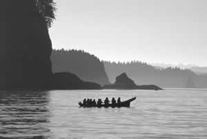 A
few of the experienced crews tried to lead the other canoes out of danger.
Away from the breaking surf and rock outcroppings. Danger was not easily
acknowledged as one of our canoes found out. They were one of the first
canoes to depart Hoh and tried to maneuver their canoe into the Queets
River but were swamped by a large swell that spilled the crew overboard,
into the cold Pacific Ocean for nearly half an hour. Luckily we were
traveling in the summer months when the water temperature at the surface
is warmer allowing for a little more exposure time before hypothermia
overcomes life functions.
A
few of the experienced crews tried to lead the other canoes out of danger.
Away from the breaking surf and rock outcroppings. Danger was not easily
acknowledged as one of our canoes found out. They were one of the first
canoes to depart Hoh and tried to maneuver their canoe into the Queets
River but were swamped by a large swell that spilled the crew overboard,
into the cold Pacific Ocean for nearly half an hour. Luckily we were
traveling in the summer months when the water temperature at the surface
is warmer allowing for a little more exposure time before hypothermia
overcomes life functions.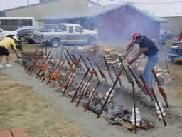
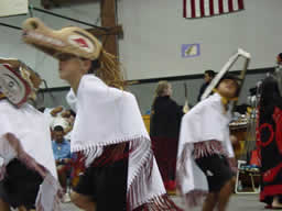
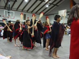
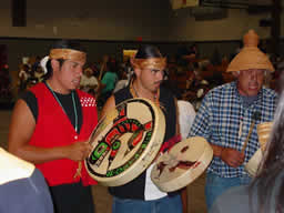
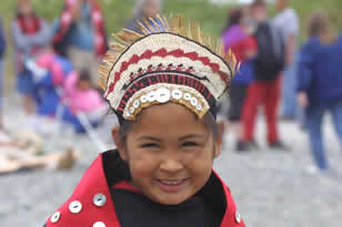
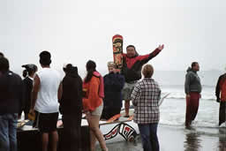
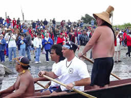 Our
Celebrations included the Welcoming Reception of the ocean going canoes
where the shores of Taholah were packed with thousands of people cheering
and respecting the crews of these canoes while honoring our Ancestors.
The Quinault Nation hosted a three day long Potlatch where each and
every crew was honored for their bravery and courage; where all of our
Chiefs from all the tribes present were recognized and honored with
eagle feathers and other gifts; where all the tribes were provided opportunities
to Potlatch in their traditional styles. Where children shared in the
festivities with their families, carrying on our ancient traditions
of being Human Beings.
Our
Celebrations included the Welcoming Reception of the ocean going canoes
where the shores of Taholah were packed with thousands of people cheering
and respecting the crews of these canoes while honoring our Ancestors.
The Quinault Nation hosted a three day long Potlatch where each and
every crew was honored for their bravery and courage; where all of our
Chiefs from all the tribes present were recognized and honored with
eagle feathers and other gifts; where all the tribes were provided opportunities
to Potlatch in their traditional styles. Where children shared in the
festivities with their families, carrying on our ancient traditions
of being Human Beings.