|
|
Canku Ota |
|
|
(Many Paths) |
||
|
An Online Newsletter Celebrating Native America |
||
|
March 10, 2001 - Issue 31 |
||
|
|
||
|
Remnants of Old Indian Tribe Documented |
||
|
by Charles Lussier The Houma Courier |
||
 Growing up along
Bayou Dularge, Janie Verret Luster knew that the ground beneath her feet was rich with the history of her ancestors. Growing up along
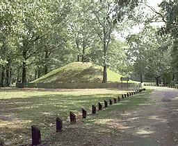
Bayou Dularge, Janie Verret Luster knew that the ground beneath her feet was rich with the history of her ancestors.As a girl, she remembers occasionally finding shards of old pottery in the mud piled along the bank, spoil from a before-she-was-born dredging of the bayou. Its a community that still has a heavy concentration of Native Americans. Several times a day as a girl, she remembers her mother, Mary Verret, rowing her and her siblings across the bayou in a pirogue to take her to the Lower Bayou Dularge Elementary School, widely known as the Indian school because only American Indians were enrolled there. Luster, who still lives along the bayou with her husband and three of her four children, was surprised recently to learn from a neighbor that two women, apparently archeologists, were checking out a tip that an Indian mound was located in the area. Luster already knew the answer. A ridge on the west side of Brady Road a mile or so from her house had long suspected to be such a mound and she was certain that it was. "I never knew whether it had been documented as an Indian mound," she said. Nevertheless, she did not walk on it, for fear that if might upset the bones of her ancestors, perhaps buried inside. But she had asked about it before. Now, she learned that the mound was in the path of a levee. Terrebonne Parish officials had long ago built a levee to protect residents on the east bank of Bayou Dularge and now they want to extend a levee to protect the west side. The levee would come as close as 10 feet away from the edge of Brady Road right through the mound unless something changed. Luster, though, was relieved to learn someone had let the authorities know about the mound, lest it be destroyed as so many other mounds have through the years. The tip prompted the government officials behind the levee project to hire Coastal Environments, a Baton Rouge-based archeological firm to investigate the mound. After a week of fact gathering in January and a couple of days of taking soil samples, the team of three archeologists came to the same conclusion Luster had. In fact, the team found evidence of not just one, but three mounds. "One was bulldozed 20 or 30 years ago," Rich Weinstein said. "Another was buried under spoil banks along Bayou Dularge." VISIONS OF THE PAST Ash, maple and sassafras trees now block the view, but the three mounds are clearly within a few hundred feet of each other. Besides the still standing mound, a second mound is now just a plowed up farmers field. The third mound along the bayou bank still stands, but its not nearly as big as the main mound, which was partially destroyed by the bayou dredging. When Luster sees this view, she gets excited and slips into the past. "You have to visualize a whole village out here," she said with a smile. Such reconstruction is her job. She works as a curator at Cannes Brulee Native American Center in the Rivertown area of Kenner. But its also in her blood. Her father lived the first seven years of his life in a palmetto hut, not that far removed from the earthen huts that once populated Bayou Dularge so many years ago. Weinstein said by carbon dating the soil, the archeologists have managed to date the mounds to somewhere between 1150 and 1400 A.D. The mounds appear to be only one layer, meaning that in all likelihood they played host to only one generation of Indians. The three mounds dont appear to be burial mounds, but they did once provide a platform for the dwellings of the highest members of the tribe, probably the chief, the head of the temple and the chiefs brother, usually the war chief, Weinstein said. On top of these mounds, the men would dig their earthen huts, covered on top with sugar cane or palmetto matting. Elton Theriot remembers playing on the mounds as a boy. He recalls only two mounds, not three, but his grandmother, Adele, a devout Roman Catholic, insisted that the mounds were of Indian origin. Adele, who lived to be 100 years old, would tell her grandson a story about neighborhood kids who were digging in one of the mounds. They found bones. Adele wouldnt have it. She ordered the boys put the bones back and cover it over. That, however, didnt stop Theriot from playing on the mound. "It didnt bother us, because we went and played on it," he said, "but you could clearly see it." That mound was on the property of a neighbor, who used it as a perch for cattle, before eventually tearing it down to plant a vegetable garden that is still there. "It was washing away because of the cattles hoofs," he remembers, "but it was prominent. It was at least two or three feet above the pasture." 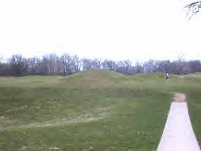 HISTORICAL SIGNIFICANCE In the world of Native American tribes that lived along the Mississippi Delta prior to the arrival of Europeans, the number of mounds indicates the size of the village. For three mounds to be located so close to one another suggests a sizeable village, Weinstein said. About five miles north along Marmande Ridge is one large verified Indian mound. That mound has several layers and stands higher than the mounds along Brady Road, but it may have been a lesser Indian outpost. "We always assumed that that was the main ridge of the swamp, but thats only a single mound," Weinstein said. The samples, however, dont say that much. For more answers, the landowner of the property would have to authorize a formal archeological investigation of the mounds. "If you had to tie somebody to it, it would probably be the Chitimacha Chawasha, or the Washa," he said. Determining exactly which tribe is difficult because the tribes in the Mississippi Delta possessed similar language and left similar forms of pottery behind, he said. "We have to use analogies to the Natchez, and a couple of other historic tribes," he said. According to state officials, the Dularge mounds are considered the 306th place of historical significance found in Terrebonne Parish since the state started counting in the early 1970s. MOVE THE LEVEE The levee plans, which so concerned Luster, may not prove that much of a problem to rewrite. "The easiest, simplest thing to do, if you can, is just move the levee," Weinstein said. Jerome Zeringue, executive director of the Terrebonne Levee and Conservation District, said he is talking with the U.S. Army Corps of Engineers to see if the federal agency will agree to allow them to "dogleg" around the mound. The levee is tentatively planned to begin construction this fall. Its estimated cost is $3 million, will stretch four miles and is expected to be complete by summer 2002. Meanwhile, Luster suspects more history is to be found beneath the ground. One of her newest neighbors, Kenneth Brunet, began developing fishing camps last year at several lots along Brady Road. He had already cleared about half the land when Luster told him that he might find shards of pottery on the property. Already possessing an interest in history, Brunet quickly noticed that pottery was embedded all over the property. He collected three bags full of the stuff and turned it over to Weinstein and company for examination. |
|
Louisiana American Indian Lesson
Plan |
|
Louisiana Indian Tribal History |
|
Indian Burial Grounds Action
Group |
|
|
||
|
|
||
|
|
||
| Canku Ota is a free Newsletter celebrating Native America, its traditions and accomplishments . We do not provide subscriber or visitor names to anyone. Some articles presented in Canku Ota may contain copyright material. We have received appropriate permissions for republishing any articles. Material appearing here is distributed without profit or monetary gain to those who have expressed an interest. This is in accordance with Title 17 U.S.C. section 107. | ||
|
Canku Ota is a copyright © 2000, 2001 of Vicki Lockard and Paul Barry. |
||
|
|
The "Canku Ota - A Newsletter Celebrating Native America" web site and its design is the |
|
|
Copyright © 1999, 2000, 2001 of Paul C. Barry. |
||
|
All Rights Reserved. |